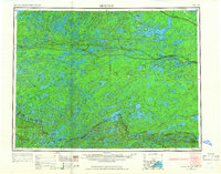
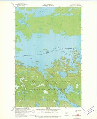
1978 Map of Brule Narrows
USGS Topo · Published 1993About this map
Rainy Lake dominates the southern landscape of this northern borderland, serving as the central waterway through which the international boundary passes. Just after the 1975 establishment of Voyageurs National Park, this survey captures the intricate network of islands and bays that define the Minnesota side of the water, including Big Island, Finlander Island, and Shelland Island. To the north and east, the Canadian wilderness is marked by the vast reaches of Quetico Provincial Park and Little Turtle Lake. The geography reveals a transition between protected American parklands and the rugged Ontario interior, linked by the Brule Narrows. On the Minnesota side, smaller inland bodies like Cruiser Lake and Shoepack Lake sit perched above the larger bay system, while the Canadian portion features industrial or mining-related nomenclature such as Bad Vermilion Lake and Shoal Lake.
Find a feature on this map
48 named features on this map. Tap any name to fly to it.
Don’t see what you’re looking for? This feature index may not catch every label — zoom into the map to look around manually.
Map Details
Editions of this 1978 Brule Narrows Map
This is the sole edition of this map. No revisions or reprints were ever made.
Other maps of this area

1954 · International Falls
USGS Topo · 1:250,000

1957 · International Falls
USGS Topo · 1:250,000
1957 · Quetico
USGS Topo · 1:250,000

1958 · International Falls
USGS Topo · 1:250,000
1963 · Redhorse Bay
USGS Topo · 1:24,000
1967 · Namakan Island
USGS Topo · 1:24,000
1967 · Hale Bay
USGS Topo · 1:24,000
1967 · Kempton Bay
USGS Topo · 1:24,000
1967 · Kettle Falls
USGS Topo · 1:24,000

1968 · Quetico
USGS Topo · 1:250,000