
1967 Map of Kempton Bay
USGS Topo · Published 1970About this map
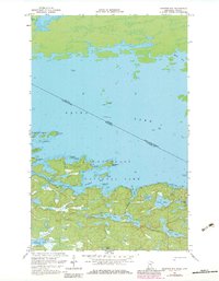
Rainy Lake dominates this 1967 survey, where the international boundary between the United States and Canada cuts across the open waters and through the northern reach of the Kabetogama State Forest. The map documents a complex archipelago of islands and rocky points, including Big Island, Kawawia Island, and Shelland Island. To the south, the interior landscape of St. Louis County is defined by a dense network of smaller bodies of water such as Oslo Lake, Beast Lake, and Cruiser Lake, separated by timbered ridges and portage trails. The presence of Stoffels Point and Idle Hour Island suggests a landscape shaped by early leisure and seasonal habitation. This study records the topographical character of the borderlands before modern development, detailing the intricate shoreline of Kempton Bay and the navigational aids like the Light positioned near Gull Rocks.
Find a feature on this map
35 named features on this map. Tap any name to fly to it.
Don’t see what you’re looking for? This feature index may not catch every label — zoom into the map to look around manually.
Map Details
Editions of this 1967 Kempton Bay Map
2 editions found
Other maps of this area

1954 · International Falls
USGS Topo · 1:250,000

1957 · International Falls
USGS Topo · 1:250,000

1958 · International Falls
USGS Topo · 1:250,000

1967 · Namakan Island
USGS Topo · 1:24,000
1967 · Kettle Falls
USGS Topo · 1:24,000

1968 · Soldier Point
USGS Topo · 1:24,000

1968 · Daley Bay
USGS Topo · 1:24,000

1968 · Ash River NE
USGS Topo · 1:24,000
1978 · Brule Narrows
USGS Topo · 1:100,000
1978 · Crane Lake
USGS Topo · 1:100,000