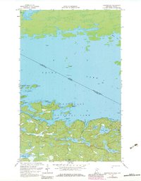
1967 Map of Kempton Bay
USGS Topo · Published 1983About this map
Voyageurs National Park defines this aquatic landscape along the international border, where the vast waters of Rainy Lake meet the intricate shoreline of northern Minnesota. The map documents a complex network of islands and interconnected waterways, including the large Big Island and smaller landmarks like Emerald Island and Junior Island. The boundary between Ontario and Minnesota cuts diagonally across the open water, passing Manitou Rock and Anchor Island as it follows the historical navigation route. Inland, the terrain is pocketed with smaller water bodies such as Shoepack Lake, Oslo Lake, and Cruiser Lake, separated by a system of portages. This 1967 survey, updated with 1980s data, illustrates the transition from the deep waters of Kempton Bay and Moose Bay to the marshy, lake-strewn interior typical of the Canadian Shield.
Find a feature on this map
37 named features on this map. Tap any name to fly to it.
Don’t see what you’re looking for? This feature index may not catch every label — zoom into the map to look around manually.
Map Details
Editions of this 1967 Kempton Bay Map
2 editions found
Other maps of this area

1954 · International Falls
USGS Topo · 1:250,000

1957 · International Falls
USGS Topo · 1:250,000

1958 · International Falls
USGS Topo · 1:250,000

1967 · Namakan Island
USGS Topo · 1:24,000

1967 · Kempton Bay
USGS Topo · 1:24,000
1967 · Kettle Falls
USGS Topo · 1:24,000

1968 · Soldier Point
USGS Topo · 1:24,000

1968 · Daley Bay
USGS Topo · 1:24,000

1968 · Ash River NE
USGS Topo · 1:24,000
1978 · Brule Narrows
USGS Topo · 1:100,000