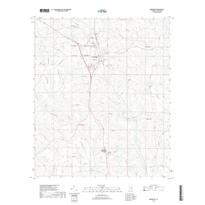
2018 Map of Brundidge
USGS Topo · Published 2018About this map
Brundidge serves as the primary hub in this corner of Pike County, where the convergence of Veterans Blvd and E Troy St highlights its role as a regional crossroads. The town is flanked by a significant concentration of family and community burial grounds, including the Brundidge City Cem, Lakeview Cem, and the nearby Fleming Cem. The landscape is defined by the headwaters and branches of numerous waterways, such as Whitewater Cr and Sandy Run Cr, which create a complex drainage pattern throughout the township. To the south, the smaller settlement of Hamilton Crossroads sits near Harris Lake, anchored by its own Hamilton Crossroads Cem. This mapping captures the rural residential and agricultural layout of the early 21st century, preserving the locations of outlying landmarks like Hopewell Cem and Williams Cem that remain vital for genealogical research.
Find a feature on this map
88 named features on this map. Tap any name to fly to it.
Don’t see what you’re looking for? This feature index may not catch every label — zoom into the map to look around manually.
Map Details
Editions of this 2018 Brundidge Map
This is the sole edition of this map. No revisions or reprints were ever made.
Other maps of this area

1948 · Brundidge
USGS Topo · 1:62,500

1950 · Brundidge
USGS Topo · 1:62,500

1953 · Dothan
USGS Topo · 1:250,000

1954 · Dothan
USGS Topo · 1:250,000

1955 · Dothan
USGS Topo · 1:250,000

1960 · Brundidge
USGS Topo · 1:24,000

1960 · Brundidge SE
USGS Topo · 1:24,000

1960 · Victoria
USGS Topo · 1:24,000

1960 · Brundidge NW
USGS Topo · 1:24,000

1962 · Brundidge
USGS Topo · 1:25,000
Featured Places
- Brundidge, AL
- Broad View, Brundidge
- Pierson Subdivision, Brundidge
- Hamilton Crossroads, AL
- Caldwell Subdivision, Brundidge