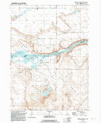
1992 Map of Bruneau Dunes
USGS Topo · Published 1992About this map
Bruneau Dunes State Park anchors the southern portion of this landscape, where the Idaho desert meets the engineered waters of the Snake River system. Edited in 1992, this sheet documents a complex irrigation and power infrastructure characterized by the C J Strike Reservoir and its associated Aqueduct and Canal systems. The terrain transitions from the high sand formations of the state park through the rugged topography of Flatiron Butte toward the river valley. Conservation interests are central to this area, as seen in the expansive Snake River Birds of Prey National Conservation Area and the Bruneau Duck Ponds. Local landmarks like Wilkins Island and Rattlesnake Springs provide historical points of reference for researchers tracing the geography of the Elmore and Owyhee county line.
Find a feature on this map
21 named features on this map. Tap any name to fly to it.
Don’t see what you’re looking for? This feature index may not catch every label — zoom into the map to look around manually.
Map Details
Editions of this 1992 Bruneau Dunes Map
This is the sole edition of this map. No revisions or reprints were ever made.
Other maps of this area

1892 · Mountain Home
USGS Topo · 1:125,000

1893 · Mountain Home
USGS Topo · 1:125,000

1947 · Bruneau
USGS Topo · 1:62,500

1947 · Indian Cove
USGS Topo · 1:24,000

1947 · Sand Dunes
USGS Topo · 1:24,000

1947 · Bruneau
USGS Topo · 1:24,000

1947 · Sugar Valley
USGS Topo · 1:24,000

1947 · Hot Spring
USGS Topo · 1:24,000

1948 · Sand Dunes
USGS Topo · 1:24,000

1948 · Indian Cove
USGS Topo · 1:24,000