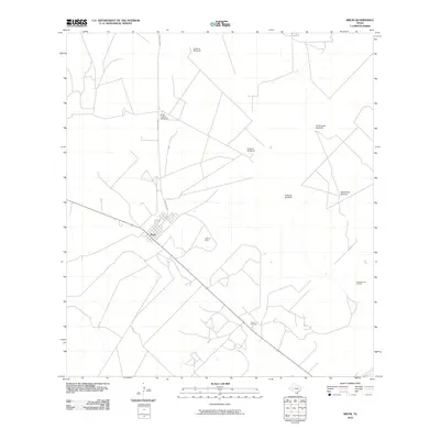
2010 Map of Bruni
USGS Topo · Published 2010About this map
Bruni serves as the primary hub of this South Texas landscape, where the intersection of transit and energy production defines the local economy. The town site is surrounded by extensive petroleum infrastructure, including the Cole Oil Field, the O'Hern Oil Field, and the Thanksgiving Oil Field. These fields suggest a landscape heavily utilized for resource extraction, punctuated by a network of ranch roads and specialized landmarks. Scattered across the arid terrain are numerous named water-pumping stations such as the El Norte Windmill, Encinos Windmill, and Aguacalosa Windmill. These features, along with Ranch Rd 2050, highlight the essential infrastructure required for cattle ranching and industry in Webb County during the early 21st century.
Find a feature on this map
11 named features on this map. Tap any name to fly to it.
Don’t see what you’re looking for? This feature index may not catch every label — zoom into the map to look around manually.
Map Details
Editions of this 2010 Bruni Map
This is the sole edition of this map. No revisions or reprints were ever made.
Other maps of this area

1939 · Bruni
USGS Topo · 1:62,500

1956 · Laredo
USGS Topo · 1:250,000

1967 · Hebbronville NW
USGS Topo · 1:24,000

1967 · Hebbronville
USGS Topo · 1:24,000

1968 · Parrilla Creek SW
USGS Topo · 1:24,000
1968 · Mills Bennett SW
USGS Topo · 1:24,000

1968 · San Pablo
USGS Topo · 1:24,000

1972 · Albercas Ranch
USGS Topo · 1:24,000

1972 · Bruni SE
USGS Topo · 1:24,000
1972 · Bruni
USGS Topo · 1:24,000