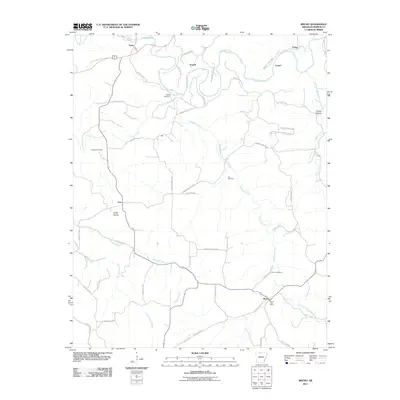
2011 Map of Bruno
USGS Topo · Published 2011About this map
Crooked Creek snakes through the northern landscape of Marion County, anchoring a region of dispersed settlements and upland prairies. This 2011 survey illustrates the rural character of the Ozarks, where small communities like Pyatt, Eros, and Bruno are linked by a dense network of county roads. The settlement pattern is deeply connected to the local topography, with names like Parker Hollow and Kings Prairie reflecting the varied terrain. Genealogists will find significant value in the distribution of family-named burial sites, including the Patton Cemetery, Stanley Cemetery, and Hall Cemetery. The southern portion of the map is dominated by the drainage of Hampton Creek and its East Fork, while the Bruno Post Office serves as a central landmark for the community near Bruno Cemetery.
Find a feature on this map
55 named features on this map. Tap any name to fly to it.
Don’t see what you’re looking for? This feature index may not catch every label — zoom into the map to look around manually.
Map Details
Editions of this 2011 Bruno Map
This is the sole edition of this map. No revisions or reprints were ever made.
Other maps of this area

1893 · Yellville
USGS Topo · 1:125,000

1903 · Yellville
USGS Topo · 1:125,000

1905 · Yellville
USGS Topo · 1:125,000

1929 · Yellville
USGS Topo · 1:125,000

1945 · Harrison
USGS Topo · 1:250,000

1949 · Harrison
USGS Topo · 1:250,000

1954 · Harrison
USGS Topo · 1:250,000

1958 · Harrison
USGS Topo · 1:250,000

1964 · Harrison
USGS Topo · 1:250,000
1966 · Yellville
USGS Topo · 1:24,000