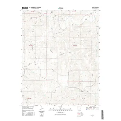
2017 Map of Bruno
USGS Topo · Published 2017About this map
Pyatt and Bruno anchor this survey of the northern Ozarks, where the terrain is defined by the winding course of Crooked Creek and its many seasonal tributaries. Small rural communities like Eros, Powell, and Turkey are connected by a network of winding county roads such as Marion Co 4010 and Co Rd 417, tracing the ridges and hollows of the Arkansas landscape. Genealogists will find several family-named burial grounds, including the Patton Cem, Stanley Cem, and Hall Cem, which indicate the deep roots of 19th and 20th-century settlement in the area. The map illustrates a reliance on natural water sources, with Ebbing Springs, Ozark Mountain Spring, and the E Fork Hampton Cr serving as landmarks across the dissected plateau. Open meadows at Kings Prairie contrast with the steeper topography of Parker Hollow, showing the varied land use between timbered hills and agricultural clearings.
Find a feature on this map
65 named features on this map. Tap any name to fly to it.
Don’t see what you’re looking for? This feature index may not catch every label — zoom into the map to look around manually.
Map Details
Editions of this 2017 Bruno Map
This is the sole edition of this map. No revisions or reprints were ever made.
Other maps of this area

1893 · Yellville
USGS Topo · 1:125,000

1903 · Yellville
USGS Topo · 1:125,000

1905 · Yellville
USGS Topo · 1:125,000

1929 · Yellville
USGS Topo · 1:125,000

1945 · Harrison
USGS Topo · 1:250,000

1949 · Harrison
USGS Topo · 1:250,000

1954 · Harrison
USGS Topo · 1:250,000

1958 · Harrison
USGS Topo · 1:250,000

1964 · Harrison
USGS Topo · 1:250,000
1966 · Yellville
USGS Topo · 1:24,000