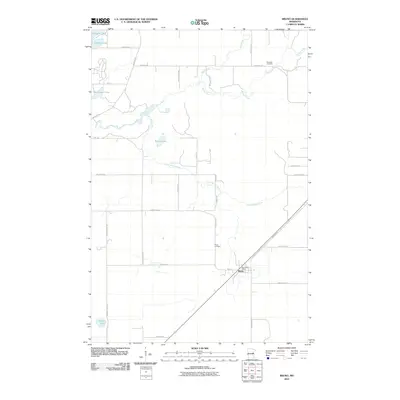
2010 Map of Bruno
USGS Topo · Published 2010About this map
Bruno serves as the primary hub for this Pine County landscape, situated at a junction where the local road network and railroad corridor meet. The settlement is positioned in a region defined by its hydrography, with several significant water bodies clustered in the northern portion of the map. Among these are Sturgeon Lake, Johnson Lake, and Big Slough Lake, which reflect the lake-rich character of eastern Minnesota. Further south, Willow Lake sits within a network of smaller drainages that eventually feed the region's river systems. This 2010 survey provides a clear view of the rural township structure and the distribution of farmsteads and rural residences that radiate from the central town site, showing the continued importance of the transportation corridor that passes through the heart of the community.
Find a feature on this map
5 named features on this map. Tap any name to fly to it.
Don’t see what you’re looking for? This feature index may not catch every label — zoom into the map to look around manually.
Map Details
Editions of this 2010 Bruno Map
This is the sole edition of this map. No revisions or reprints were ever made.
Other maps of this area

1953 · Duluth
USGS Topo · 1:250,000

1958 · Duluth
USGS Topo · 1:250,000

1961 · Sandstone
USGS Topo · 1:62,500

1961 · Moose Lake
USGS Topo · 1:62,500

1962 · Bruno
USGS Topo · 1:62,500

1962 · Cloverdale
USGS Topo · 1:62,500

1980 · Sandstone
USGS Topo · 1:100,000
1981 · Askov Lookout Tower
USGS Topo · 1:24,000
1981 · Kerrick
USGS Topo · 1:24,000

1981 · Willow River
USGS Topo · 1:24,000