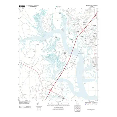
2011 Map of Brunswick West
USGS Topo · Published 2011About this map
Blythe Island and Hermitage Island define the intricate estuarine landscape of this coastal Georgia region, where the Turtle River and Buffalo River converge. The intricate network of tidal creeks and marshes, including Pyles Marsh and Dillard Creek, surrounds established residential pockets and historical landmarks. Genealogists will find a significant concentration of burial sites, from the larger Palmetto Cemetery and Greenwood Cemetery in the east to smaller family and community grounds like Maxwells Cemetery, Scarlett Cemetery, and Allen Memorial Cemetery.
Find a feature on this map
105 named features on this map. Tap any name to fly to it.
Don’t see what you’re looking for? This feature index may not catch every label — zoom into the map to look around manually.
Map Details
Editions of this 2011 Brunswick West Map
This is the sole edition of this map. No revisions or reprints were ever made.
Other maps of this area

1918 · Everett City
USGS Topo · 1:62,500

1918 · Bladen
USGS Topo · 1:62,500

1920 · Everett City
USGS Topo · 1:62,500

1921 · Darien
USGS Topo · 1:62,500

1939 · Bladen
USGS Topo · 1:62,500

1944 · Everett City
USGS Topo · 1:62,500

1945 · Brunswick
USGS Topo · 1:62,500

1946 · Brunswick
USGS Topo · 1:250,000

1948 · Brunswick
USGS Topo · 1:250,000
1956 · Bladen
USGS Topo · 1:24,000