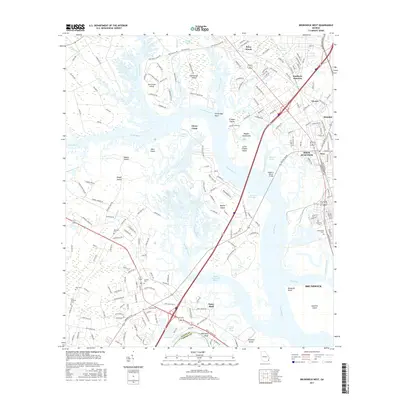
2017 Map of Brunswick West
USGS Topo · Published 2017About this map
Southern Junction and Dock Junction anchor the industrial and transit corridor of this coastal Georgia landscape, where the Turtle River and South Brunswick River wind through a complex system of marshes and islands. The 2017 data reveals the modern footprint of Brunswick and surrounding communities like Glynco and Arco, set against the sprawling wetlands of Buffalo Swamp and Dixon Swamp. For those researching local families, several established burial sites are clearly marked, including Palmetto Cem, Greenwood Cem, and the more secluded Scarlett Cem. The map illustrates the connectivity of the region via the Joseph B Mercer Bridge and the extensive development on Blythe Island, while also documenting the historical boundary line where Glynn County meets Camden County at the Little Satilla River.
Find a feature on this map
211 named features on this map. Tap any name to fly to it.
Don’t see what you’re looking for? This feature index may not catch every label — zoom into the map to look around manually.
Map Details
Editions of this 2017 Brunswick West Map
This is the sole edition of this map. No revisions or reprints were ever made.
Other maps of this area

1918 · Everett City
USGS Topo · 1:62,500

1918 · Bladen
USGS Topo · 1:62,500

1920 · Everett City
USGS Topo · 1:62,500

1921 · Darien
USGS Topo · 1:62,500

1939 · Bladen
USGS Topo · 1:62,500

1944 · Everett City
USGS Topo · 1:62,500

1945 · Brunswick
USGS Topo · 1:62,500

1946 · Brunswick
USGS Topo · 1:250,000

1948 · Brunswick
USGS Topo · 1:250,000
1956 · Bladen
USGS Topo · 1:24,000