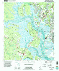
1993 Map of Brunswick West
USGS Topo · Published 1995About this map
Blythe Island and the complex tidal network of the Turtle River dominate this coastal survey, where the marshlands of the Georgia coast meet the western edge of Brunswick. The landscape is defined by the transition from industrial areas like Southern Junction and the CSX Transportation rail corridors to the expansive reaches of Pyles Marsh and Buffalo Swamp. To the west, inland settlements like Fancy Bluff and Glynn Camp are connected by roads such as Emanuel Church Road. The map documents a diverse mix of land uses, from the Blythe Island Regional Park and various boat ramps to the Industrial Waste Pond facilities that support the local economy. Genealogists will find numerous small burial grounds and rural houses of worship, including Lipthratt Cem, Maxwell Cem, and Greenland Ch.
Find a feature on this map
76 named features on this map. Tap any name to fly to it.
Don’t see what you’re looking for? This feature index may not catch every label — zoom into the map to look around manually.
Map Details
Editions of this 1993 Brunswick West Map
This is the sole edition of this map. No revisions or reprints were ever made.
Other maps of this area

1918 · Everett City
USGS Topo · 1:62,500

1918 · Bladen
USGS Topo · 1:62,500

1920 · Everett City
USGS Topo · 1:62,500

1921 · Darien
USGS Topo · 1:62,500

1939 · Bladen
USGS Topo · 1:62,500

1944 · Everett City
USGS Topo · 1:62,500

1945 · Brunswick
USGS Topo · 1:62,500

1946 · Brunswick
USGS Topo · 1:250,000

1948 · Brunswick
USGS Topo · 1:250,000
1956 · Bladen
USGS Topo · 1:24,000