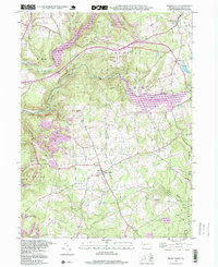
1998 Map of Brush Valley
USGS Topo · Published 1999About this map
Brush Valley and Penn Run anchor this landscape in Indiana County, which is defined by a series of major water management and conservation projects. The map shows the expansive Yellow Creek Lake within Yellow Creek State Park, as well as the southern reaches of the Two Lick Reservoir. Extensive industrial activity is evident through numerous Strip Mines clustered west of Two Lick Creek and near Moose Hill. For genealogists and local historians, the sheet is particularly dense with small family and community burial grounds, including the Harmony Cem, Brush Valley Cem, Evans Cem, and Frye Cem. Scattered small settlements like Luciusboro, Waterman, and Littletown reflect the rural township character, while landmarks like Stake Ch and a Radio Tower near Strongs Hill provide specific points of interest for historical researchers.
Find a feature on this map
44 named features on this map. Tap any name to fly to it.
Don’t see what you’re looking for? This feature index may not catch every label — zoom into the map to look around manually.
Map Details
Editions of this 1998 Brush Valley Map
This is the sole edition of this map. No revisions or reprints were ever made.
Other maps of this area

1902 · Indiana
USGS Topo · 1:62,500

1902 · Barnesboro
USGS Topo · 1:62,500

1904 · Barnesboro
USGS Topo · 1:62,500

1904 · Johnstown
USGS Topo · 1:62,500

1907 · Johnstown
USGS Topo · 1:62,500

1920 · New Florence
USGS Topo · 1:62,500

1921 · New Florence
USGS Topo · 1:48,000

1922 · New Florence
USGS Topo · 1:62,500

1943 · Punxsutawney
USGS Topo · 1:125,000

1944 · New Florence
USGS Topo · 1:62,500
Featured Places
- Brush Valley Township, PA
- Rico, Brush Valley Township
- Center Township, PA
- Suncliff, Brush Valley Township
- Cherryhill Township, PA