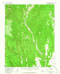
1957 Map of Brushy Basin Wash
USGS Topo · Published 1964About this map
Manti-La Sal National Forest dominates this landscape, where the high mesas of southeastern Utah are deeply incised by the drainage of Brushy Basin Wash and Cottonwood Creek. The map records a complex cultural history through numerous Cliff Dwelling and Cliff Dwellings sites scattered among the alcoves of Comb Ridge and Arch Canyon. Indigenous history is further marked by the presence of an Indian Village and a local Cemetery situated along Allen Canyon Creek.
Find a feature on this map
62 named features on this map. Tap any name to fly to it.
Don’t see what you’re looking for? This feature index may not catch every label — zoom into the map to look around manually.
Map Details
Editions of this 1957 Brushy Basin Wash Map
4 editions found

Other maps of this area

1886 · Abajo
USGS Topo · 1:250,000

1892 · Abajo
USGS Topo · 1:250,000

1893 · Abajo
USGS Topo · 1:250,000

1935 · Elk Ridge
USGS Topo · 1:96,000

1940 · Elk Ridge
USGS Topo · 1:125,000

1954 · Elk Ridge 4 NW
USGS Topo · 1:24,000

1954 · Elk Ridge 1 SW
USGS Topo · 1:24,000

1954 · Elk Ridge 2 SE
USGS Topo · 1:24,000

1954 · Elk Ridge 3 NE
USGS Topo · 1:24,000

1954 · Elk Ridge 1 SE
USGS Topo · 1:24,000