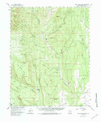
1957 Map of Brushy Basin Wash
USGS Topo · Published 1984About this map
Indian Village and the Cemetery north of it sit along the winding course of Cottonwood Wash in this 1957 survey of San Juan County. This mid-century map, produced with cooperation from the Atomic Energy Commission, documents a landscape of dramatic topography where the massive wall of Comb Ridge bisects the terrain. The presence of a Landing Strip and numerous Jeep Trails cutting through Brushy Basin Wash and Cottonwood Canyon indicates the post-war era of uranium exploration and remote land management.
Find a feature on this map
49 named features on this map. Tap any name to fly to it.
Don’t see what you’re looking for? This feature index may not catch every label — zoom into the map to look around manually.
Map Details
Editions of this 1957 Brushy Basin Wash Map
4 editions found

Other maps of this area

1886 · Abajo
USGS Topo · 1:250,000

1892 · Abajo
USGS Topo · 1:250,000

1893 · Abajo
USGS Topo · 1:250,000

1935 · Elk Ridge
USGS Topo · 1:96,000

1940 · Elk Ridge
USGS Topo · 1:125,000

1954 · Elk Ridge 4 NW
USGS Topo · 1:24,000

1954 · Elk Ridge 1 SW
USGS Topo · 1:24,000

1954 · Elk Ridge 2 SE
USGS Topo · 1:24,000

1954 · Elk Ridge 3 NE
USGS Topo · 1:24,000

1954 · Elk Ridge 1 SE
USGS Topo · 1:24,000