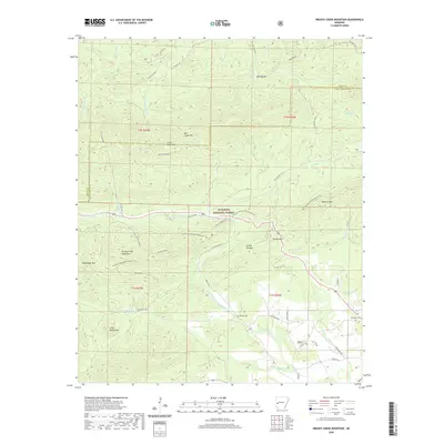
2020 Map of Brushy Creek Mountain
USGS Topo · Published 2020About this map
Ouachita National Forest dominates this Arkansas landscape, where the ridge-and-valley topography of Montgomery and Scott Counties is meticulously documented. The terrain is defined by prominent elevations such as Brushy Creek Mountain and Turkey Pen Mtn, which frame the central drainage of Big Brushy Creek. Human presence is marked by narrow forest service corridors like Nat For Dev Rd 6 and the long-distance Ouachita National Recreation Trail, which traverses the high ground of Salmon Mtn and Rockhouse Mtn. Toward the southern edge, small family or community landmarks appear, including Brushy Cem and Grenade Cem. This survey illustrates the remote character of the region, where the economy is tied to the managed forest and outdoor recreation rather than dense settlement. The map captures the intricate network of headwater streams, such as Little Cedar Cr and W Fork Big Cedar Cr, as they descend from named heights like Wolf Divide and Mill Creek Mtn.
Find a feature on this map
49 named features on this map. Tap any name to fly to it.
Don’t see what you’re looking for? This feature index may not catch every label — zoom into the map to look around manually.
Map Details
Editions of this 2020 Brushy Creek Mountain Map
This is the sole edition of this map. No revisions or reprints were ever made.
Other maps of this area

1887 · Mount Ida #2
USGS Topo · 1:62,500

1890 · Mount Ida
USGS Topo · 1:125,000

1955 · Little Rock
USGS Topo · 1:250,000

1956 · Little Rock
USGS Topo · 1:250,000

1959 · Oden
USGS Topo · 1:62,500

1959 · Mount Ida
USGS Topo · 1:62,500

1960 · Little Rock
USGS Topo · 1:250,000

1960 · Gravelly
USGS Topo · 1:62,500
1960 · Parks
USGS Topo · 1:62,500

1964 · Little Rock
USGS Topo · 1:250,000