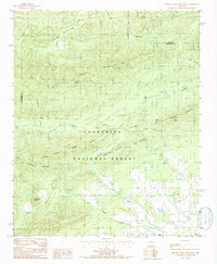
1985 Map of Brushy Creek Mountain
USGS Topo · Published 1986About this map
Ouachita National Forest dominates this mid-1980s landscape, where the ridges of Mill Creek Mountain, Turkey Pen Mountain, and Blowout Mountain form a complex topography of the Arkansas interior. The small settlement of Oden sits in the southeast, near the confluence of Polk Creek and Brushy Creek, while the Big Brushy Recreation Site serves as a hub for wilderness access. Land use is a mix of conservation and resource extraction, evidenced by a Shale Pit and various trails traversing the forest floor.
Find a feature on this map
30 named features on this map. Tap any name to fly to it.
Don’t see what you’re looking for? This feature index may not catch every label — zoom into the map to look around manually.
Map Details
Editions of this 1985 Brushy Creek Mountain Map
This is the sole edition of this map. No revisions or reprints were ever made.
Other maps of this area

1887 · Mount Ida #2
USGS Topo · 1:62,500

1890 · Mount Ida
USGS Topo · 1:125,000

1955 · Little Rock
USGS Topo · 1:250,000

1956 · Little Rock
USGS Topo · 1:250,000

1959 · Oden
USGS Topo · 1:62,500

1959 · Mount Ida
USGS Topo · 1:62,500

1960 · Little Rock
USGS Topo · 1:250,000

1960 · Gravelly
USGS Topo · 1:62,500
1960 · Parks
USGS Topo · 1:62,500

1964 · Little Rock
USGS Topo · 1:250,000