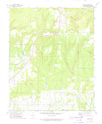
1973 Map of Brushy
USGS Topo · Published 1974About this map
The Home of Sequoyah stands as a central historical landmark in this region of Sequoyah County, situated just north of the Akins settlement. The landscape is defined by the prominent Brushy Mountains and Rocky Mountain, which separate the northern drainages like Dry Creek and Brushy Creek from the expansive southern lowlands near Prices Chapel. Local community life in the early 1970s is evidenced by numerous civic and religious sites, including the Brushy Sch, Rocky Point Ch, and the Sequoyah Cem. The map reveals a network of hollows such as Polecat Hollow and Mud Spring Hollow that feed into larger water bodies like Brushy Lake and the meandering Big Skin Bayou, illustrating the traditional Ozark plateau settlement patterns where homes and roads followed the narrow valley floors between steep ridges like Long Ridge.
Find a feature on this map
48 named features on this map. Tap any name to fly to it.
Don’t see what you’re looking for? This feature index may not catch every label — zoom into the map to look around manually.
Map Details
Editions of this 1973 Brushy Map
2 editions found
Other maps of this area

1898 · Tahlequah
USGS Topo · 1:125,000

1900 · Sallisaw
USGS Topo · 1:125,000

1901 · Tahlequah
USGS Topo · 1:125,000

1905 · Tahlequah
USGS Topo · 1:125,000

1911 · Sallisaw
USGS Topo · 1:125,000

1946 · Fort Smith
USGS Topo · 1:250,000

1965 · Fort Smith
USGS Topo · 1:250,000
1966 · Muldrow
USGS Topo · 1:24,000

1966 · Gans
USGS Topo · 1:24,000

1967 · Fort Smith
USGS Topo · 1:250,000