
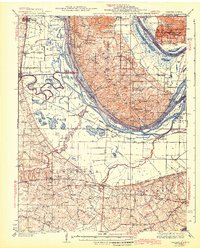
1943 Map of Brussels
USGS Topo · Published 1943About this map
The Mississippi River creates a complex landscape of islands and sloughs as it passes through the bottomlands of the Cuivre and Dardenne districts. This mid-century survey reveals a river-driven economy and social life, where numerous landings like Hastings Ldg, Martin Ldg, and Miller Ldg facilitated transport before the dominance of modern bridges. In Calhoun Co, the Golden Eagle Ferry provides a vital link across the water. On the Missouri side, the Wabash and Chicago and Burlington railroads serve growing communities such as O'Fallon and St Peters.
Find a feature on this map
108 named features on this map. Tap any name to fly to it.
Don’t see what you’re looking for? This feature index may not catch every label — zoom into the map to look around manually.
Map Details
Editions of this 1943 Brussels Map
2 editions found
Other maps of this area

1903 · O'Fallon
USGS Topo · 1:125,000

1924 · Robertson
USGS Topo · 1:24,000

1927 · St. Charles
USGS Topo · 1:62,500

1930 · Hardin
USGS Topo · 1:62,500

1930 · Jerseyville
USGS Topo · 1:62,500

1931 · Brussels
USGS Topo · 1:62,500

1932 · Manchester NE
USGS Topo · 1:24,000

1933 · Creve Coeur
USGS Topo · 1:24,000

1933 · Jerseyville
USGS Topo · 1:62,500

1933 · Saint Charles
USGS Topo · 1:62,500