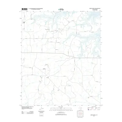
2013 Map of Bryans Mill
USGS Topo · Published 2013About this map
The Cusseta Mountains rise as a prominent topographic feature in this corner of Cass County, anchoring the small settlements of Cusseta and Bryans Mill. The landscape is a complex network of creeks and drainage basins, with Whatley Cr and Powell Cr flowing through the timbered terrain toward the expansive Wright Patman Lake in the northeast. This 2013 survey reflects the area's dual character of rural tradition and industrial utility, evidenced by the presence of the Bryans Mill Gas Plant alongside numerous family and community landmarks. Genealogists will find the locations of several burial grounds preserved here, including Pleasant Hill Cem, Powell Cem, and Floyd Hill Cem, which serve as vital points of reference for the region's historic family lines.
Find a feature on this map
56 named features on this map. Tap any name to fly to it.
Don’t see what you’re looking for? This feature index may not catch every label — zoom into the map to look around manually.
Map Details
Editions of this 2013 Bryans Mill Map
This is the sole edition of this map. No revisions or reprints were ever made.
Other maps of this area
1909 · New Boston
USGS Topo · 1:62,500
1910 · Linden
USGS Topo · 1:62,500
1914 · Daingerfield
USGS Topo · 1:62,500
1930 · Bassett
USGS Topo · 1:62,500

1953 · Texarkana
USGS Topo · 1:250,000
1955 · Corley
USGS Topo · 1:24,000
1955 · Maud
USGS Topo · 1:24,000
1955 · New Boston
USGS Topo · 1:62,500
1956 · Texarkana
USGS Topo · 1:250,000
1965 · Marietta
USGS Topo · 1:24,000