
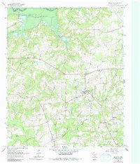
1965 Map of Marietta
USGS Topo · Published 1967About this map
Marietta serves as the focal point for this mid-1960s survey of the Cass County countryside, where small rural settlements are linked by a winding network of local roads. The landscape is defined by the significant hydrological influence of the Sulphur River and the expansive waters of Lake Texarkana at the northern boundary. Genealogists will find a high density of rural burial sites and places of worship, including Bethlehem Ch and its associated Bethlehem Cem, as well as New Hope Ch and Bell Cem. These features, alongside named locations like Bryans Mill and Cornett, reveal a pattern of dispersed agricultural communities. The St Louis Southwestern railroad cuts through the northwestern corner near Jennings Lake, marking the era's remaining industrial transport lines through the timbered creek bottoms of Bear Creek and Floyd Creek.
Find a feature on this map
32 named features on this map. Tap any name to fly to it.
Don’t see what you’re looking for? This feature index may not catch every label — zoom into the map to look around manually.
Map Details
Editions of this 1965 Marietta Map
2 editions found
Other maps of this area

1909 · New Boston
USGS Topo · 1:62,500

1910 · Linden
USGS Topo · 1:62,500

1914 · Daingerfield
USGS Topo · 1:62,500

1930 · Bassett
USGS Topo · 1:62,500

1953 · Texarkana
USGS Topo · 1:250,000

1955 · Corley
USGS Topo · 1:24,000

1955 · New Boston
USGS Topo · 1:62,500

1956 · Texarkana
USGS Topo · 1:250,000

1964 · Daingerfield
USGS Topo · 1:24,000

1965 · Dalby Springs
USGS Topo · 1:24,000