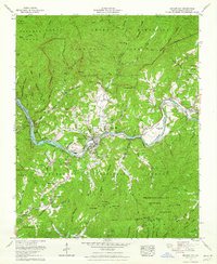
1961 Map of Bryson City
USGS Topo · Published 1964About this map
Bryson City sits at a pivotal topographical junction where the Tuckasegee River meets the southern reaches of the Great Smoky Mountains National Park. This 1961 revision captures the local landscape as the Southern Railway winds through the river valley, connecting smaller settlements like Franklin Grove and Ela. The map serves as a vital genealogical record, locating numerous family burial grounds including Upper Noland Cem, Wiggins-Watson Cem, and Sultan Cem, alongside rural landmarks like the Antioch Ch and Sherrill Gap Church. The western portion of the sheet is dominated by the waters of Lake Fontana, while to the east, the Cherokee Indian Reservation Qualla Tract begins. The density of named gaps and ridges, such as Davis Gap and Sunkota Ridge, illustrates the complex geography that dictated early Appalachian transit and settlement patterns.
Find a feature on this map
78 named features on this map. Tap any name to fly to it.
Don’t see what you’re looking for? This feature index may not catch every label — zoom into the map to look around manually.
Map Details
Editions of this 1961 Bryson City Map
Other maps of this area

1886 · Knoxville
USGS Topo · 1:125,000

1891 · Cowee
USGS Topo · 1:125,000

1892 · Knoxville
USGS Topo · 1:125,000

1893 · Mt Guyot
USGS Topo · 1:125,000

1894 · Knoxville
USGS Topo · 1:125,000

1895 · Knoxville
USGS Topo · 1:125,000

1897 · Cowee
USGS Topo · 1:125,000

1901 · Knoxville
USGS Topo · 1:125,000

1907 · Cowee
USGS Topo · 1:125,000

1912 · Mt Guyot
USGS Topo · 1:125,000