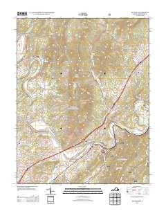
2013 Map of Buchanan
USGS Topo · Published 2013About this map
Buchanan serves as the focal point of this modern topographic study, where the James River snakes through the Botetourt County landscape. The settlement patterns follow the river's winding path, notably at the dramatic Horseshoe Bend and through the narrow passage of The Gorge. Transportation history is visible in landmarks like the Springwood Truss Bridge near Springwood and the concentrated grid of streets in the town center, including Albemarle Ave and Culpepper Ave.
Find a feature on this map
93 named features on this map. Tap any name to fly to it.
Don’t see what you’re looking for? This feature index may not catch every label — zoom into the map to look around manually.
Map Details
Editions of this 2013 Buchanan Map
This is the sole edition of this map. No revisions or reprints were ever made.
Other maps of this area

1890 · Roanoke
USGS Topo · 1:125,000

1891 · Roanoke
USGS Topo · 1:125,000

1894 · Natural Bridge
USGS Topo · 1:125,000

1894 · Natural Bridge
USGS Topo · 1:62,500

1907 · Natural Bridge Special
USGS Topo · 1:62,500

1913 · Eagle Rock
USGS Topo · 1:48,000

1915 · Eagle Rock
USGS Topo · 1:62,500

1929 · Roanoke
USGS Topo · 1:48,000

1933 · Roanoke
USGS Topo · 1:62,500

1947 · Roanoke
USGS Topo · 1:250,000