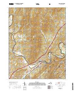
2019 Map of Buchanan
USGS Topo · Published 2019About this map
The James River dictates the geography of this Botetourt County landscape, carving through the terrain at Horseshoe Bend and creating the dramatic passage known as The Gorge. The town of Buchanan serves as the central hub, where Main St and Culpepper Ave meet near the riverbanks. To the west, the settlement of Springwood is marked by the Springwood Truss Bridge, while the surrounding hills are dotted with family and community burial sites including Fairview Cem, Shafer Cem, and Mays Cem.
Find a feature on this map
89 named features on this map. Tap any name to fly to it.
Don’t see what you’re looking for? This feature index may not catch every label — zoom into the map to look around manually.
Map Details
Editions of this 2019 Buchanan Map
This is the sole edition of this map. No revisions or reprints were ever made.
Other maps of this area

1890 · Roanoke
USGS Topo · 1:125,000

1891 · Roanoke
USGS Topo · 1:125,000

1894 · Natural Bridge
USGS Topo · 1:125,000

1894 · Natural Bridge
USGS Topo · 1:62,500

1907 · Natural Bridge Special
USGS Topo · 1:62,500

1913 · Eagle Rock
USGS Topo · 1:48,000

1915 · Eagle Rock
USGS Topo · 1:62,500

1929 · Roanoke
USGS Topo · 1:48,000

1933 · Roanoke
USGS Topo · 1:62,500

1947 · Roanoke
USGS Topo · 1:250,000