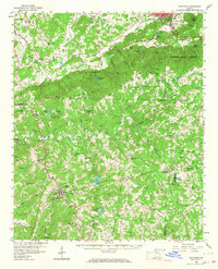
1958 Map of Buchanan
USGS Topo · Published 1968About this map
Dugdown Mountain creates a significant topographic barrier across the center of this Georgia landscape, separating the ridge-and-valley country of Cedartown and Rockmart from the southern plateau. The Tallapoosa River and its tributaries, such as Water Mill Creek, drain the southern half, where the Haralson County seat of Buchanan sits as a regional crossroads. This late 1950s survey shows a rural economy transitioning from early industry to modern utility, featuring Abernathys Mill and several quarries alongside a growing network of state highways like Georgia 27.
Find a feature on this map
92 named features on this map. Tap any name to fly to it.
Don’t see what you’re looking for? This feature index may not catch every label — zoom into the map to look around manually.
Map Details
Editions of this 1958 Buchanan Map
2 editions found

Other maps of this area

1886 · Rome
USGS Topo · 1:125,000

1889 · Tallapoosa
USGS Topo · 1:125,000

1890 · Cartersville
USGS Topo · 1:125,000

1891 · Marietta
USGS Topo · 1:125,000

1891 · Cartersville
USGS Topo · 1:125,000

1892 · Tallapoosa
USGS Topo · 1:125,000

1895 · Marietta
USGS Topo · 1:125,000

1896 · Cartersville
USGS Topo · 1:125,000

1897 · Marietta
USGS Topo · 1:125,000

1897 · Tallapoosa
USGS Topo · 1:125,000