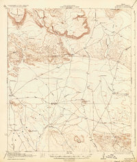
1925 Map of Buck Hill
USGS Topo · Published 1934About this map
Kokernot Ranch and the O 2 Ranch anchor this West Texas survey, capturing a remote landscape of high desert ranching before the mid-century. The terrain is dominated by massive volcanic features like Elephant Mtn and Mitchell Mesa, which rise sharply above the drainages of Calamity Creek and Terlingua Creek. This 1917 survey reflects a period when survival depended on sparse water sources and primitive improvements, evident in the network of windmills such as Cobas Windmill and Brush Windmill. Human presence is marked by isolated homesteads like Sid Place and the already noted Loy Place (Abandoned), connected only by rough tracks leading toward Alpine or Terlingua. The presence of Stone Tank and Broken Tank further illustrates the critical infrastructure required to maintain cattle in this arid reach of Brewster County.
Find a feature on this map
33 named features on this map. Tap any name to fly to it.
Don’t see what you’re looking for? This feature index may not catch every label — zoom into the map to look around manually.
Map Details
Editions of this 1925 Buck Hill Map
3 editions found

Other maps of this area

1895 · Alpine
USGS Topo · 1:125,000

1917 · Agua Fria
USGS Topo · 1:62,500

1917 · Tascotal Mesa
USGS Topo · 1:62,500

1917 · Santiago Peak
USGS Topo · 1:62,500

1917 · Buck Hill
USGS Topo · 1:62,500

1918 · Bone Spring
USGS Topo · 1:125,000

1918 · Buck Hill
USGS Topo · 1:62,500

1918 · Santiago Peak
USGS Topo · 1:62,500

1918 · Jordan Gap
USGS Topo · 1:62,500

1918 · Nine Point Mesa
USGS Topo · 1:62,500