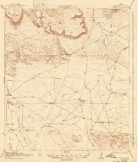
1925 Map of Buck Hill
USGS Topo · Published 1944About this map
Mitchell Mesa and Elephant Mtn dominate this West Texas landscape, where life revolves around scarce water sources and expansive cattle operations. The topography is defined by significant landmarks like Buck Hill and Butcherknife Hill, interspersed with drainages such as Calamity Creek and Walnut Draw. These watercourses provided the essential lifelines for early 20th-century ranching, as evidenced by the distribution of family holdings including the Kokernot Ranch and Wilsons Ranch.
Find a feature on this map
33 named features on this map. Tap any name to fly to it.
Don’t see what you’re looking for? This feature index may not catch every label — zoom into the map to look around manually.
Map Details
Editions of this 1925 Buck Hill Map
3 editions found

Other maps of this area

1895 · Alpine
USGS Topo · 1:125,000

1917 · Agua Fria
USGS Topo · 1:62,500

1917 · Tascotal Mesa
USGS Topo · 1:62,500

1917 · Santiago Peak
USGS Topo · 1:62,500

1917 · Buck Hill
USGS Topo · 1:62,500

1918 · Bone Spring
USGS Topo · 1:125,000

1918 · Buck Hill
USGS Topo · 1:62,500

1918 · Santiago Peak
USGS Topo · 1:62,500

1918 · Jordan Gap
USGS Topo · 1:62,500

1918 · Nine Point Mesa
USGS Topo · 1:62,500