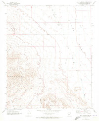
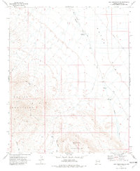
1970 Map of Buck Mountains SE
USGS Topo · Published 1973About this map
Mohave Mountains and the northern slopes of Black Mountain dominate this arid landscape, where desert topography is defined by complex drainage systems and isolated water sources. Published in the early 1970s, the map reveals a remote region where survival and movement depended on a few critical points like Lower Well WT, Shot Up Tank, and Lower Tank. The presence of a Pipeline and scattered Jeep Trails cutting through the terrain suggests industrial or utility infrastructure encroaching on the high desert. Significant drainage basins, including the Dutch Flat Wash and Mohave Wash, illustrate the natural pathways through the foothills, while the Deer Canyon provides one of the few named topographical breaks in the western mountains. This survey serves as a precise record of the Mohave County desert before any significant modern development or expansion altered these traditional landmarks.
Find a feature on this map
14 named features on this map. Tap any name to fly to it.
Don’t see what you’re looking for? This feature index may not catch every label — zoom into the map to look around manually.
Map Details
Editions of this 1970 Buck Mountains SE Map
2 editions found
Other maps of this area

1911 · Parker
USGS Topo · 1:125,000

1923 · Signal
USGS Topo · 1:250,000

1927 · Buck Mountains
USGS Topo · 1:62,500

1929 · Buck Mountains
USGS Topo · 1:62,500

1942 · Signal
USGS Topo · 1:250,000

1943 · Giers Basin
USGS Topo · 1:62,500

1950 · Prescott
USGS Topo · 1:250,000

1954 · Needles
USGS Topo · 1:250,000

1954 · Prescott
USGS Topo · 1:250,000

1956 · Needles
USGS Topo · 1:250,000