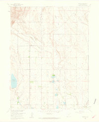
1960 Map of Buckeye
USGS Topo · Published 1962About this map
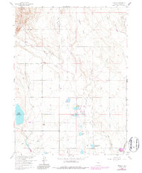
Buckeye and the surrounding Larimer County ranch lands are defined by a complex network of 1960s-era water management systems designed to sustain agriculture in this high-plains environment. The landscape is crisscrossed by irrigation features such as the North Poudre Ditch, the Park Creek Lateral, and the Buckeye Lateral, which move water across the undulating terrain. To the north, the elevation rises toward Gilman Mountain, while the southern reaches are punctuated by substantial water storage sites including Reservoir No 15 and Boxelder Res No 1. Transport and transit history are visible in the path of the Union Pacific railroad and a distinct Old Railroad Grade that cuts through the center of the sheet near Ripple. This survey captures a specific moment in the mid-century development of the Missouri River Basin, where infrastructure like Wellington drainage and numerous ditches illustrate the region's reliance on engineered waterways.
Find a feature on this map
22 named features on this map. Tap any name to fly to it.
Don’t see what you’re looking for? This feature index may not catch every label — zoom into the map to look around manually.
Map Details
Editions of this 1960 Buckeye Map
5 editions found
Other maps of this area

1906 · Fort Collins
USGS Topo · 1:62,500

1907 · Livermore
USGS Topo · 1:125,000

1908 · Fort Collins
USGS Topo · 1:62,500

1908 · Eaton
USGS Topo · 1:125,000

1909 · Livermore
USGS Topo · 1:125,000

1910 · Eaton
USGS Topo · 1:125,000

1954 · Greeley
USGS Topo · 1:250,000

1957 · Greeley
USGS Topo · 1:250,000

1958 · Greeley
USGS Topo · 1:250,000

1960 · Livermore
USGS Topo · 1:24,000