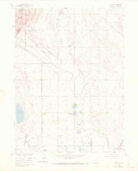
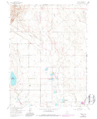
1960 Map of Buckeye
USGS Topo · Published 1972About this map
Gilman Mountain overlooks a landscape defined by the intricate water management systems of northern Larimer County. The irrigation network is prominently displayed through features like the Buckeye Pacific Union Lateral and Buckeye Lateral, which feed into numerous water bodies including Reservoir No 15 and Bubbles Lake. This 1960 field-checked survey highlights the agricultural and industrial infrastructure of the era, from the small settlement at Buckeye to the petroleum operations within the Wellington Field. Traces of earlier transportation methods remain visible via an Old Railroad Grade cutting across the central plains. The map also records the flow of Rawhide Creek through Rawhide Flats and the course of Spottlewood Creek, documenting the vital relationship between the local terrain and the water resources required for the region's development.
Find a feature on this map
24 named features on this map. Tap any name to fly to it.
Don’t see what you’re looking for? This feature index may not catch every label — zoom into the map to look around manually.
Map Details
Editions of this 1960 Buckeye Map
5 editions found
Other maps of this area

1906 · Fort Collins
USGS Topo · 1:62,500

1907 · Livermore
USGS Topo · 1:125,000

1908 · Fort Collins
USGS Topo · 1:62,500

1908 · Eaton
USGS Topo · 1:125,000

1909 · Livermore
USGS Topo · 1:125,000

1910 · Eaton
USGS Topo · 1:125,000

1954 · Greeley
USGS Topo · 1:250,000

1957 · Greeley
USGS Topo · 1:250,000

1958 · Greeley
USGS Topo · 1:250,000

1960 · Livermore
USGS Topo · 1:24,000