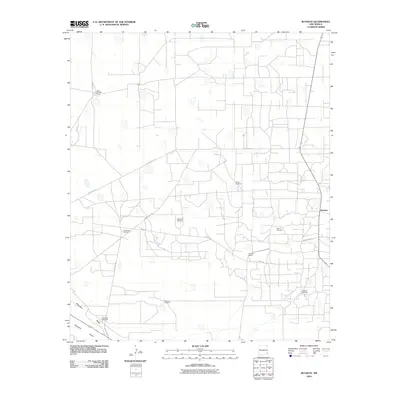
2010 Map of Buckeye
USGS Topo · Published 2010About this map
The Querecho Plains and the prominent escarpment of Mescalero Ridge dominate this corner of the Llano Estacado in the early 21st century. The map reveals an arid landscape defined by its reliance on subterranean water, evidenced by a network of scattered water sources including North Windmill, East Mytie Windmill, and Jenkins Windmill. This rural infrastructure supports cattle operations such as the John Williams Ranch and Buckeye Ranch, which are connected by a grid of unpaved roads and routes like County Rd-125 and the thoroughfare labeled Texas CP. The small settlement of Buckeye sits on the eastern edge of the quadrangle, serving as a focal point for the surrounding ranching community in this high-desert environment.
Find a feature on this map
16 named features on this map. Tap any name to fly to it.
Don’t see what you’re looking for? This feature index may not catch every label — zoom into the map to look around manually.
Map Details
Editions of this 2010 Buckeye Map
This is the sole edition of this map. No revisions or reprints were ever made.
Other maps of this area

1954 · Hobbs
USGS Topo · 1:250,000

1958 · Hobbs
USGS Topo · 1:250,000

1962 · Lovington
USGS Topo · 1:62,500

1962 · Buckeye
USGS Topo · 1:62,500

1963 · Monument
USGS Topo · 1:62,500

1963 · Laguna Gatuna
USGS Topo · 1:62,500

1984 · Ironhouse Well
USGS Topo · 1:24,000

1984 · Laguna Gatuna NW
USGS Topo · 1:24,000
1985 · Buckeye NW
USGS Topo · 1:24,000
1985 · Lovington NW
USGS Topo · 1:24,000