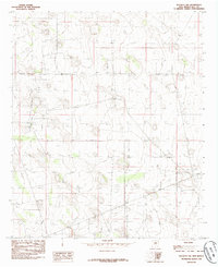
1985 Map of Buckeye NW
USGS Topo · Published 1985About this map
Dean Ranch and Fort Ranch anchor this high-plains landscape of Lea County, characterized by a sparse, industrial settlement pattern during the mid-1980s. The map illustrates a complex infrastructure for resource extraction and water management, notably featuring an extensive Aqueduct system and a dedicated Pumping Sta that supported operations in the desert environment. Small community centers such as Maljamar and Buckeye serve as the primary hubs in an otherwise open expanse of ranchlands and section lines.
Find a feature on this map
13 named features on this map. Tap any name to fly to it.
Don’t see what you’re looking for? This feature index may not catch every label — zoom into the map to look around manually.
Map Details
Editions of this 1985 Buckeye NW Map
This is the sole edition of this map. No revisions or reprints were ever made.
Other maps of this area

1954 · Hobbs
USGS Topo · 1:250,000

1954 · Brownfield
USGS Topo · 1:250,000

1958 · Brownfield
USGS Topo · 1:250,000

1958 · Hobbs
USGS Topo · 1:250,000

1962 · Brownfield
USGS Topo · 1:250,000

1962 · Buckeye
USGS Topo · 1:62,500

1963 · Maljamar
USGS Topo · 1:62,500

1973 · Fort Ranch
USGS Topo · 1:24,000

1973 · Dean Ranch
USGS Topo · 1:24,000
1973 · Cedar Point SE
USGS Topo · 1:24,000