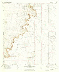
1973 Map of Cedar Point SE
USGS Topo · Published 1976About this map
Mescalero Ridge dominates this 1970s landscape, forming the dramatic western edge of the Llano Estacado. This escarpment, also labeled as the Caprock, creates a sharp topographic break between the elevated plains to the east and the lower desert terrain to the west, where shifting sand is noted. The map captures a moment of intense industrial activity in the Permian Basin, evidenced by the extensive Caprock Oil Field and the Tulk Oil Field to the southeast. Dozens of individual oil wells and drill holes are scattered across the terrain, connected by a network of jeep trails and pipelines. Local ranching history is represented by the Medlin Ranch and Zimmerman Ranch, while communication infrastructure is highlighted by the KBIM radio tower.
Find a feature on this map
15 named features on this map. Tap any name to fly to it.
Don’t see what you’re looking for? This feature index may not catch every label — zoom into the map to look around manually.
Map Details
Editions of this 1973 Cedar Point SE Map
2 editions found
Other maps of this area

1954 · Hobbs
USGS Topo · 1:250,000

1954 · Brownfield
USGS Topo · 1:250,000

1958 · Brownfield
USGS Topo · 1:250,000

1958 · Hobbs
USGS Topo · 1:250,000

1962 · Brownfield
USGS Topo · 1:250,000

1962 · Buckeye
USGS Topo · 1:62,500

1963 · Maljamar
USGS Topo · 1:62,500
1973 · Cedar Point
USGS Topo · 1:24,000

1973 · Caudill Ranch
USGS Topo · 1:24,000

1973 · Cooper-Good Ranch
USGS Topo · 1:24,000