
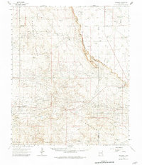
1963 Map of Maljamar
USGS Topo · Published 1965About this map
Mescalero (The Caprock) Ridge bisects this landscape, marking a dramatic geological transition between the high plains and the lower desert basins of Southeast New Mexico. During the early 1960s, the region's economy was defined by its dual identity as ranch land and a growing oil patch. Evidence of this is seen in the proximity of established holdings like Bond Ranch and Anderson Ranch to the industrial infrastructure of the Maljamar and Loco Hills areas. The map details an extensive network of pipelines and pumping stations serving the oil fields, interspersed with natural landmarks such as North Square Lake and the Cedar Lake Breaks. On the Querecho Plains, the small settlement of Youngs and the worker-oriented Booker Camp reflect the human footprint within this sparse, resource-driven environment.
Find a feature on this map
26 named features on this map. Tap any name to fly to it.
Don’t see what you’re looking for? This feature index may not catch every label — zoom into the map to look around manually.
Map Details
Editions of this 1963 Maljamar Map
2 editions found
Other maps of this area

1942 · Clayton Basin
USGS Topo · 1:62,500

1943 · Clayton Basin
USGS Topo · 1:62,500

1943 · Oil City
USGS Topo · 1:62,500

1951 · King Camp
USGS Topo · 1:24,000

1953 · Basin Well
USGS Topo · 1:24,000

1954 · Carlsbad
USGS Topo · 1:250,000

1954 · Hobbs
USGS Topo · 1:250,000

1954 · Brownfield
USGS Topo · 1:250,000

1955 · Red Lake SE
USGS Topo · 1:24,000

1955 · Roswell
USGS Topo · 1:250,000