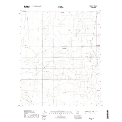
2020 Map of Buckeye
USGS Topo · Published 2020About this map
Buckeye anchors this corner of the Llano Estacado, situated in a landscape defined by industrial and ranching road networks. The topographic relief is punctuated by the prominent Mescalero Ridge in the southwest, a significant escarpment that separates the higher plains from the lower desert basins. The map documents an intricate web of access routes including Texas Camp Rd, Querecho Rd, and Williams Rd, which serve the local oil, gas, and cattle operations characteristic of Lea County. The presence of Texas Camp reflects the region's history of temporary and semi-permanent industrial outposts. This survey detail captures the modern footprint of land use in the Permian Basin, showing how traditional land divisions like t17s r34e intersect with contemporary infrastructure such as Buckeye Rd.
Find a feature on this map
19 named features on this map. Tap any name to fly to it.
Don’t see what you’re looking for? This feature index may not catch every label — zoom into the map to look around manually.
Map Details
Editions of this 2020 Buckeye Map
This is the sole edition of this map. No revisions or reprints were ever made.
Other maps of this area

1954 · Hobbs
USGS Topo · 1:250,000

1958 · Hobbs
USGS Topo · 1:250,000

1962 · Lovington
USGS Topo · 1:62,500

1962 · Buckeye
USGS Topo · 1:62,500

1963 · Monument
USGS Topo · 1:62,500

1963 · Laguna Gatuna
USGS Topo · 1:62,500

1984 · Ironhouse Well
USGS Topo · 1:24,000

1984 · Laguna Gatuna NW
USGS Topo · 1:24,000
1985 · Buckeye NW
USGS Topo · 1:24,000
1985 · Lovington NW
USGS Topo · 1:24,000