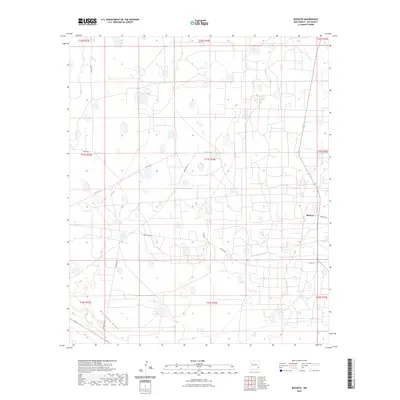
2023 Map of Buckeye
USGS Topo · Published 2023About this map
Mescalero Ridge cuts through the southwestern corner of this Lea County landscape, defining the transition between the high plains and the lower desert basins. The settlement of Buckeye sits at the intersection of several local thoroughfares, serving as a focal point for the region's cattle and oil-related traffic. The map reveals an intricate network of rural roads and tracks, such as Querecho Rd and Texas Camp Rd, which crisscross the grid-like townships. These routes connect isolated outposts like Texas Camp and various ranching properties, reflecting the sparse but functional human presence across the Llano Estacado. The topography is characterized by numerous small, intermittent depressions and basins typical of this arid environment, managed within the Public Land Survey System framework of Range 33 East through Range 35 East.
Find a feature on this map
19 named features on this map. Tap any name to fly to it.
Don’t see what you’re looking for? This feature index may not catch every label — zoom into the map to look around manually.
Map Details
Editions of this 2023 Buckeye Map
This is the sole edition of this map. No revisions or reprints were ever made.
Other maps of this area

1954 · Hobbs
USGS Topo · 1:250,000

1958 · Hobbs
USGS Topo · 1:250,000

1962 · Lovington
USGS Topo · 1:62,500

1962 · Buckeye
USGS Topo · 1:62,500

1963 · Monument
USGS Topo · 1:62,500

1963 · Laguna Gatuna
USGS Topo · 1:62,500

1984 · Ironhouse Well
USGS Topo · 1:24,000

1984 · Laguna Gatuna NW
USGS Topo · 1:24,000
1985 · Buckeye NW
USGS Topo · 1:24,000
1985 · Lovington NW
USGS Topo · 1:24,000