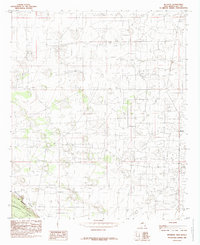
1985 Map of Buckeye
USGS Topo · Published 1985About this map
Mescalero Ridge, also known locally as The Caprock, creates a dramatic elevation change in this part of Lea County, separating the high mesa from the lower Querecho Plains. The landscape is dominated by the extensive infrastructure of a vast Oil Field, which is marked by a dense network of roads and numerous well sites. The small settlement of Buckeye serves as a focal point for the region's industrial activity, supported by a large Aqueduct and a Pumping Sta that provide essential water and utility transport through the arid terrain. This 1985 provisional map reflects the intensive land use required for energy extraction, showing how petroleum development has reshaped the natural environment of southeast New Mexico.
Find a feature on this map
10 named features on this map. Tap any name to fly to it.
Don’t see what you’re looking for? This feature index may not catch every label — zoom into the map to look around manually.
Map Details
Editions of this 1985 Buckeye Map
This is the sole edition of this map. No revisions or reprints were ever made.
Other maps of this area

1954 · Hobbs
USGS Topo · 1:250,000

1958 · Hobbs
USGS Topo · 1:250,000

1962 · Lovington
USGS Topo · 1:62,500

1962 · Buckeye
USGS Topo · 1:62,500

1963 · Monument
USGS Topo · 1:62,500

1963 · Laguna Gatuna
USGS Topo · 1:62,500

1984 · Ironhouse Well
USGS Topo · 1:24,000

1984 · Laguna Gatuna NW
USGS Topo · 1:24,000
1985 · Buckeye NW
USGS Topo · 1:24,000
1985 · Lovington NW
USGS Topo · 1:24,000