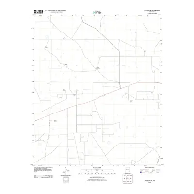
2010 Map of Buckeye NE
USGS Topo · Published 2010About this map
Hume Oil Field and Kemnitz Oil Field define the industrial character of this desert landscape in Lea County. The grid of service roads and pipeline corridors serves as a stark reminder of the region's primary economic engine during the early 21st century. Interspersed between these industrial zones are legacies of the high plains ranching tradition, marked by named outposts like Chambers Sheep Camp and several family-named ranch properties. Water management is central to survival in this arid terrain, evidenced by the persistence of Garrett Windmill, East Windmill, and Middle Well. These landmarks provide critical orientation points across a landscape otherwise dominated by a strictly regulated network of county roads including County Rd-101 and County Rd-117.
Find a feature on this map
15 named features on this map. Tap any name to fly to it.
Don’t see what you’re looking for? This feature index may not catch every label — zoom into the map to look around manually.
Map Details
Editions of this 2010 Buckeye NE Map
This is the sole edition of this map. No revisions or reprints were ever made.
Other maps of this area

1954 · Hobbs
USGS Topo · 1:250,000

1954 · Brownfield
USGS Topo · 1:250,000

1958 · Brownfield
USGS Topo · 1:250,000

1958 · Hobbs
USGS Topo · 1:250,000

1962 · Brownfield
USGS Topo · 1:250,000
1962 · Lovington
USGS Topo · 1:62,500
1962 · Buckeye
USGS Topo · 1:62,500
1970 · Hillburn City SW
USGS Topo · 1:24,000
1973 · Fort Ranch
USGS Topo · 1:24,000
1973 · Dean Ranch
USGS Topo · 1:24,000