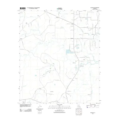
2012 Map of Buckeye
USGS Topo · Published 2012About this map
Big Island Oil Field sits at the heart of this landscape, marking the industrial footprint on a terrain defined by bayous and prairies. The map records a rural network where small settlements like Buckeye and Deville are connected by roads named for local families, such as Saint Clair Ryder Rd and Elmus Paul Rd. The drainage patterns of Slash Bayou and Big Cr weave through distinctive clearings like Vasher Prairie and Little Prairie, showing the unique Louisiana interplay between marshy lowlands and slightly elevated plains. For genealogists, the density of family burial grounds is remarkable, with sites like Newell Cem, Hopewell Cem, and Bradford Cem scattered across the quadrangle, preserving the names of the generations who settled this part of Avoyelles Parish.
Find a feature on this map
102 named features on this map. Tap any name to fly to it.
Don’t see what you’re looking for? This feature index may not catch every label — zoom into the map to look around manually.
Map Details
Editions of this 2012 Buckeye Map
This is the sole edition of this map. No revisions or reprints were ever made.
Other maps of this area

1935 · Lecompte
USGS Topo · 1:62,500

1940 · Marksville
USGS Topo · 1:62,500

1941 · Alexandria
USGS Topo · 1:62,500

1941 · Buckeye
USGS Topo · 1:62,500

1953 · Alexandria
USGS Topo · 1:250,000

1955 · Alexandria
USGS Topo · 1:250,000

1957 · Alexandria
USGS Topo · 1:62,500

1957 · Lecompte
USGS Topo · 1:62,500

1959 · Buckeye
USGS Topo · 1:62,500
1962 · Marksville
USGS Topo · 1:62,500