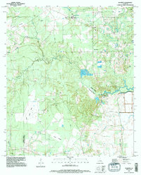
1994 Map of Buckeye
USGS Topo · Published 1996About this map
Low-lying prairie lands and intricate bayou networks define this landscape near the boundary of Rapides Parish and Avoyelles Parish. The settlement patterns of Buckeye and Deville are documented alongside numerous family and church burial grounds, such as Newell Cem and the Catholic Cem, reflecting generations of rural community life. The terrain is marked by distinctive named expanses like Little Prairie and Long Prairie, which are separated by the winding course of Big Creek.
Find a feature on this map
44 named features on this map. Tap any name to fly to it.
Don’t see what you’re looking for? This feature index may not catch every label — zoom into the map to look around manually.
Map Details
Editions of this 1994 Buckeye Map
This is the sole edition of this map. No revisions or reprints were ever made.
Other maps of this area

1935 · Lecompte
USGS Topo · 1:62,500

1940 · Marksville
USGS Topo · 1:62,500

1941 · Alexandria
USGS Topo · 1:62,500

1941 · Buckeye
USGS Topo · 1:62,500

1953 · Alexandria
USGS Topo · 1:250,000

1955 · Alexandria
USGS Topo · 1:250,000

1957 · Alexandria
USGS Topo · 1:62,500

1957 · Lecompte
USGS Topo · 1:62,500

1959 · Buckeye
USGS Topo · 1:62,500
1962 · Marksville
USGS Topo · 1:62,500