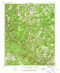
1943 Map of Buckhart
USGS Topo · Published 1965About this map
Bryant Creek and its many tributaries, including Hunter Creek and Fox Creek, carve a complex network of ridges and hollows across this portion of the Ozark Plateau. During the early 1940s, this landscape was defined by small, isolated communities and an exceptionally high density of rural schools, such as Turkey Flat Sch, Bakerfield Sch, and Silver Shade Sch. The map reveals a social geography where life centered around local hubs like Rockbridge, Gentryville, and Vera Cruz.
Find a feature on this map
97 named features on this map. Tap any name to fly to it.
Don’t see what you’re looking for? This feature index may not catch every label — zoom into the map to look around manually.
Map Details
Editions of this 1943 Buckhart Map
2 editions found
Other maps of this area

1934 · Gainesville
USGS Topo · 1:48,000

1936 · Thornfield
USGS Topo · 1:48,000

1936 · Ava
USGS Topo · 1:48,000

1937 · Buckhart
USGS Topo · 1:48,000

1939 · Topaz
USGS Topo · 1:62,500

1940 · Gainesville
USGS Topo · 1:62,500

1941 · Topaz
USGS Topo · 1:62,500

1942 · Ava
USGS Topo · 1:62,500

1943 · Thornfield
USGS Topo · 1:62,500

1943 · Buckhart
USGS Topo · 1:62,500