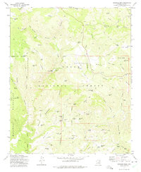
1973 Map of Buckhead Mesa
USGS Topo · Published 1975About this map
The landmark Tonto Natural Bridge stands as a focal point in this 1973 survey of the Arizona high country. Located within the Tonto National Forest, the landscape transitions from the heights of Strawberry Mtn and Buckhead Mesa down toward the deep drainages of the East Verde River. The map documents a significant mining presence in the late 20th century, with several workings such as the White Mtn Mine, Gowan Mine, and Crackerjack Mine scattered across the eastern slopes. A sophisticated network of ranching infrastructure is evident through the numerous water catchments like Bradshaw Tank and Horsethief Tank, which supported livestock across the White Hills. The southwestern portion of the quadrangle is defined by the protected boundaries of the Mazatzal Wilderness, where the terrain is marked by steep canyons and named water sources like Walnut Spring.
Find a feature on this map
85 named features on this map. Tap any name to fly to it.
Don’t see what you’re looking for? This feature index may not catch every label — zoom into the map to look around manually.
Map Details
Editions of this 1973 Buckhead Mesa Map
3 editions found
Other maps of this area

1887 · Verde
USGS Topo · 1:250,000

1892 · Verde
USGS Topo · 1:250,000

1929 · Turret Peak
USGS Topo · 1:125,000

1933 · Turret Peak
USGS Topo · 1:125,000

1934 · Pine
USGS Topo · 1:62,500

1936 · Payson
USGS Topo · 1:48,000

1940 · Pine
USGS Topo · 1:62,500

1942 · Payson
USGS Topo · 1:62,500

1952 · Pine
USGS Topo · 1:62,500

1954 · Holbrook
USGS Topo · 1:250,000