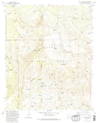
1973 Map of Buckhead Mesa
USGS Topo · Published 1986About this map
Tonto National Forest and the Mazatzal Wilderness dominate this high-desert landscape in central Arizona, captured during a 1973 field check. The geography is defined by a series of dramatic drainages, most notably Pine Creek and the Verde River, which carve through the Buckhead Mesa and Brushy Mesa. Notable landmarks like Tonto Natural Bridge highlight the unique geological formations of the area, while a network of isolated tanks such as Buckhead Tank and Bradshaw Tank reveal the critical role of water management in this arid cattle and timber country.
Find a feature on this map
76 named features on this map. Tap any name to fly to it.
Don’t see what you’re looking for? This feature index may not catch every label — zoom into the map to look around manually.
Map Details
Editions of this 1973 Buckhead Mesa Map
3 editions found
Other maps of this area

1887 · Verde
USGS Topo · 1:250,000

1892 · Verde
USGS Topo · 1:250,000

1929 · Turret Peak
USGS Topo · 1:125,000

1933 · Turret Peak
USGS Topo · 1:125,000

1934 · Pine
USGS Topo · 1:62,500

1936 · Payson
USGS Topo · 1:48,000

1940 · Pine
USGS Topo · 1:62,500

1942 · Payson
USGS Topo · 1:62,500

1952 · Pine
USGS Topo · 1:62,500

1954 · Holbrook
USGS Topo · 1:250,000