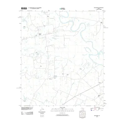
2010 Map of Buckhorn
USGS Topo · Published 2010About this map
The Brazos River meanders sharply through the eastern landscape, defining the character of this region in Austin County. Rural settlements and family-named landmarks are scattered throughout the quadrangle, including the community of Buckhorn and the oil-producing district of Raccoon Bend. The map is particularly rich in genealogical sites, preserving the locations of numerous burial grounds such as Apperson Cemetery, Carlisle Cemetery, and the Staehle Cemeteries.
Find a feature on this map
35 named features on this map. Tap any name to fly to it.
Don’t see what you’re looking for? This feature index may not catch every label — zoom into the map to look around manually.
Map Details
Editions of this 2010 Buckhorn Map
This is the sole edition of this map. No revisions or reprints were ever made.
Other maps of this area

1930 · Brenham
USGS Topo · 1:62,500

1953 · Seguin
USGS Topo · 1:250,000

1954 · Austin
USGS Topo · 1:250,000

1956 · Bellville
USGS Topo · 1:62,500

1956 · Sealy
USGS Topo · 1:62,500

1956 · Hempstead
USGS Topo · 1:62,500

1956 · Brenham
USGS Topo · 1:62,500

1958 · Seguin
USGS Topo · 1:250,000
1960 · Sunny Side
USGS Topo · 1:24,000
1961 · Burleigh
USGS Topo · 1:24,000