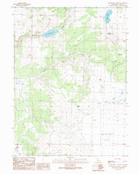
1989 Map of Buckhorn Canyon
USGS Topo · Published 1989About this map
Buckhorn Reservoir 5584 T serves as a primary water source in this high-elevation landscape of Lassen County, where the terrain is defined by dramatic changes in relief between Buckhorn Canyon and the surrounding peaks. The map reveals an area reliant on natural and improved water sources, with numerous springs such as Accommodation Spring, Harrison Spring, and the uniquely named Wire Corral Spring providing vital points of interest for local history and land use studies. The expansive Painters Flat dominates the southeastern portion of the quadrangle, contrasting with the high points of Button Mountain and Horn 6195. This landscape is navigated primarily by 4WD trails, indicating a remote environment where drainage systems like Painters Creek and Cottonwood Creek dictate the local geography. The presence of Dry Lake and various wells further illustrates the complex hydrology of this high-desert region during the late 1980s.
Find a feature on this map
23 named features on this map. Tap any name to fly to it.
Don’t see what you’re looking for? This feature index may not catch every label — zoom into the map to look around manually.
Map Details
Editions of this 1989 Buckhorn Canyon Map
This is the sole edition of this map. No revisions or reprints were ever made.
Other maps of this area

1886 · Honey Lake
USGS Topo · 1:250,000

1886 · Granite Range
USGS Topo · 1:250,000

1891 · Honey Lake
USGS Topo · 1:250,000

1893 · Honey Lake
USGS Topo · 1:250,000

1894 · Granite Range
USGS Topo · 1:250,000

1954 · Observation Peak
USGS Topo · 1:62,500

1954 · Shinn Mountain
USGS Topo · 1:62,500

1955 · Westwood
USGS Topo · 1:250,000

1955 · Lovelock
USGS Topo · 1:250,000

1958 · Westwood
USGS Topo · 1:250,000