
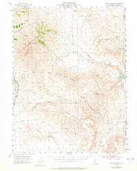
1954 Map of Shinn Mountain
USGS Topo · Published 1956About this map
Shinn Mountain and the surrounding high desert of Lassen County define this landscape along the California-Nevada border. The map documents a sparsely populated ranching and grazing region where water sources are the primary landmarks, evidenced by numerous named flows such as McKissick Spring, Juniper Jim Spring, and Toms Cabin Spring. The presence of Shinn Ranch and Post Camp suggests the era's seasonal livestock operations, while an isolated Airstrip near Smoke Creek points to the increasing importance of aerial access in remote basin-and-range country.
Find a feature on this map
46 named features on this map. Tap any name to fly to it.
Don’t see what you’re looking for? This feature index may not catch every label — zoom into the map to look around manually.
Map Details
Editions of this 1954 Shinn Mountain Map
2 editions found
Other maps of this area

1886 · Honey Lake
USGS Topo · 1:250,000

1886 · Granite Range
USGS Topo · 1:250,000

1891 · Honey Lake
USGS Topo · 1:250,000

1893 · Honey Lake
USGS Topo · 1:250,000

1894 · Granite Range
USGS Topo · 1:250,000

1954 · Wendel
USGS Topo · 1:62,500

1954 · Observation Peak
USGS Topo · 1:62,500

1954 · Litchfield
USGS Topo · 1:62,500

1954 · Karlo
USGS Topo · 1:62,500

1954 · Ravendale
USGS Topo · 1:62,500