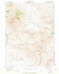
1954 Map of Shinn Mountain
USGS Topo · Published 1965About this map
Shinn Mountain and the high desert peaks of eastern Lassen County dominate this landscape near the California-Nevada border. In the mid-1950s, the area's geography was defined by a critical network of springs and water management infrastructure essential for high-altitude ranching. Named locations like Shinn Ranch and Post Camp serve as primary human markers in an otherwise topographical expanse of ridges and canyons.
Find a feature on this map
44 named features on this map. Tap any name to fly to it.
Don’t see what you’re looking for? This feature index may not catch every label — zoom into the map to look around manually.
Map Details
Editions of this 1954 Shinn Mountain Map
2 editions found

Other maps of this area

1886 · Honey Lake
USGS Topo · 1:250,000

1886 · Granite Range
USGS Topo · 1:250,000

1891 · Honey Lake
USGS Topo · 1:250,000

1893 · Honey Lake
USGS Topo · 1:250,000

1894 · Granite Range
USGS Topo · 1:250,000

1954 · Wendel
USGS Topo · 1:62,500

1954 · Observation Peak
USGS Topo · 1:62,500

1954 · Litchfield
USGS Topo · 1:62,500

1954 · Karlo
USGS Topo · 1:62,500

1954 · Ravendale
USGS Topo · 1:62,500