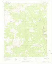
1963 Map of Buckhorn Lakes
USGS Topo · Published 1966About this map
Cimarron Ridge defines the high elevation landscape of this area on the border of Ouray, Montrose, and Gunnison counties during the early 1960s. The map captures a high country economy transitioning between traditional ranching and resource extraction, with the Comerer Ranch and Jutten Cabin established near water sources like Onion Creek and Billy Creek. Evidence of early mining activity is visible at the Tyler Mine and another unnamed mine to the east, while the Uncompahgre National Forest encompasses the eastern reaches including the Coons Reservoir. A network of high altitude trails, including the Deer Creek Trail and various unpaved routes, navigate the complex terrain surrounding peaks like Storm King and the steep passage at Slagle Pass. The abundance of alpine water features such as Buckhorn Lakes, Jutten Lakes, and Onion Lakes highlights the seasonal hydrology that supported both local livestock and regional forest management.
Find a feature on this map
28 named features on this map. Tap any name to fly to it.
Don’t see what you’re looking for? This feature index may not catch every label — zoom into the map to look around manually.
Map Details
Editions of this 1963 Buckhorn Lakes Map
3 editions found
Other maps of this area

1902 · Ouray
USGS Topo · 1:62,500

1904 · Ouray
USGS Topo · 1:62,500

1909 · Montrose
USGS Topo · 1:125,000

1911 · Montrose
USGS Topo · 1:125,000

1956 · Cimarron
USGS Topo · 1:24,000

1956 · Montrose
USGS Topo · 1:250,000

1957 · Cerro Summit
USGS Topo · 1:24,000

1959 · Montrose
USGS Topo · 1:250,000

1960 · Montrose
USGS Topo · 1:250,000
1962 · Montrose East
USGS Topo · 1:24,000