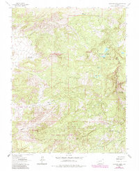
1963 Map of Buckhorn Lakes
USGS Topo · Published 1984About this map
The Cimarron Ridge dominates the eastern landscape of this 1963 survey, forming a dramatic natural boundary between Ouray, Montrose, and Gunnison counties. The area is characterized by high-elevation water systems, including Buckhorn Lakes, Julien Lakes, and Onion Lakes, which feed the drainages of Beaton Creek and Onion Creek. Evidence of early 20th-century land use appears at the Comerer Ranch and the remote Julien Cabin, while a solitary Mine near the ridge suggests the historical search for mineral wealth in these peaks.
Find a feature on this map
26 named features on this map. Tap any name to fly to it.
Don’t see what you’re looking for? This feature index may not catch every label — zoom into the map to look around manually.
Map Details
Editions of this 1963 Buckhorn Lakes Map
3 editions found
Other maps of this area

1902 · Ouray
USGS Topo · 1:62,500

1904 · Ouray
USGS Topo · 1:62,500

1909 · Montrose
USGS Topo · 1:125,000

1911 · Montrose
USGS Topo · 1:125,000

1956 · Cimarron
USGS Topo · 1:24,000

1956 · Montrose
USGS Topo · 1:250,000

1957 · Cerro Summit
USGS Topo · 1:24,000

1959 · Montrose
USGS Topo · 1:250,000

1960 · Montrose
USGS Topo · 1:250,000
1962 · Montrose East
USGS Topo · 1:24,000