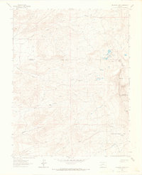
1963 Map of Buckhorn Lakes
USGS Topo · Published 1966About this map
Cimarron Ridge dominates this 1963 survey, where high-altitude peaks like Storm King and Castle Rock overlook a landscape defined by seasonal drainages and early twentieth-century industry. The map captures a moment when mining and ranching footprints remained prominent, as evidenced by the Tyler Mine and Comerer Ranch. Movement through this high country was largely dictated by the Jeep Trail and Deer Trail networks, which provided access to remote locations like Jutten Cabin and the Uncompahgre National Forest.
Find a feature on this map
28 named features on this map. Tap any name to fly to it.
Don’t see what you’re looking for? This feature index may not catch every label — zoom into the map to look around manually.
Map Details
Editions of this 1963 Buckhorn Lakes Map
3 editions found
Other maps of this area

1902 · Ouray
USGS Topo · 1:62,500

1904 · Ouray
USGS Topo · 1:62,500

1909 · Montrose
USGS Topo · 1:125,000

1911 · Montrose
USGS Topo · 1:125,000

1956 · Cimarron
USGS Topo · 1:24,000

1956 · Montrose
USGS Topo · 1:250,000

1957 · Cerro Summit
USGS Topo · 1:24,000

1959 · Montrose
USGS Topo · 1:250,000

1960 · Montrose
USGS Topo · 1:250,000
1962 · Montrose East
USGS Topo · 1:24,000